
 Across Medieval Russia
Maps of the Baltic Lands
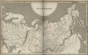
These maps depict the lands bordering the Baltic Sea, including Russia, Scandinavia and Northern Europe. They are from the Atlas to Freeman's Historical Geography, edited by J.B. Bury, Longmans Green and Co. Third Edition, 1903, and are online here at the Medieval History site.
The Medieval Atlas is a directory of maps, charts, geographic drawings and illustrations, illuminations, and other cartographic representations of the world in general, and the geography of Europe in particular, during the Middle Ages. Both historical maps and period or "antique" maps are included. The maps display the changing face of northern Europe throughout the Middle Ages. Go to the site;
http://historymedren.about.com/library/atlas/blatrusdex.htm
http://historymedren.about.com/library/atlas/blatrusdex.htm
Nessun commento:
Posta un commento